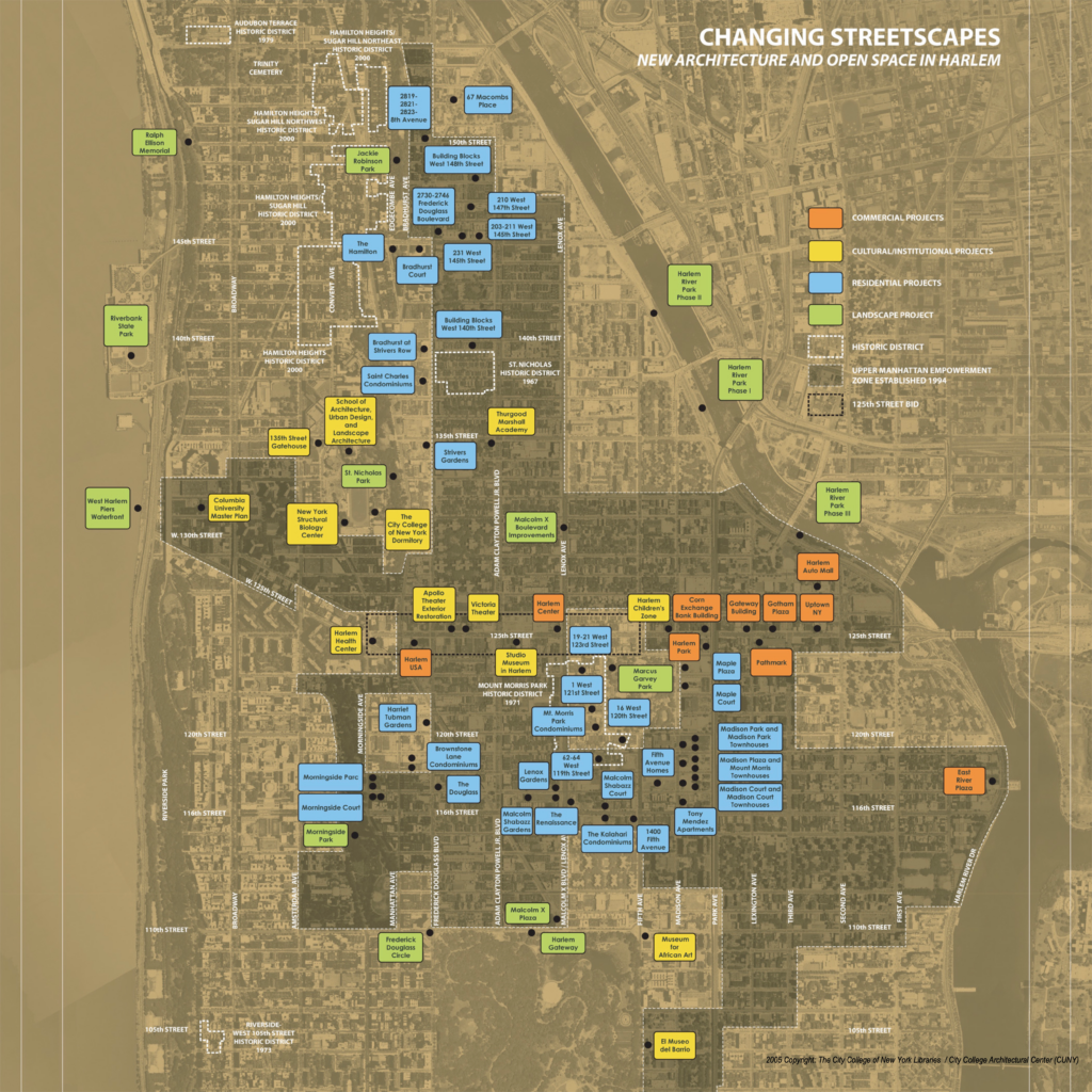
The success and volume of recent development in Harlem reflects a change in thinking about neighborhood planning that has evolved over the past 20 years. During the 1940s through 60s under Urban Renewal, Harlem saw extensive top-down redevelopment that radically altered the landscape, often displacing residents from their homes and communities with little knowledge of or voice in this process.
The rethinking in government came in part from the insistence by Harlem’s citizens groups and elected officials on residents having a say in planning and land use decisions that affect their communities. The Bradhurst Urban Renewal Plan was an example of this change and, as such, its adoption by the city is a watershed event in the history of New York city planning. The plan of operation adopted by city agencies grew out of the community’s vision to restore vacant buildings and blocks to an improved image of the neighborhood as it once had been–rather than as a wholesale clearance and rebuilding. The 1992 study that formed the basis for the city’s plan was undertaken jointly by City College Architectural Center and Columbia University’s Urban Technical Assistance Program (UTAP) at the request of the community-based organization Consortium for Central Harlem Development.
More recent planning initiatives described in this exhibit reflect a similar path, in which the impetus for change in zoning and land-use policy comes from within the community. Where members of the community have organized and led, the city has followed. A current planning initiative in which the city is boldly leading is the 125th Street River to River Study. Here, the city’s Department of City Planning and Economic Development Corporation are working closely together in coordinating a process that involves numerous city agencies and seeks broad community input in developing the best possible planning framework for the future of Harlem’s main commercial corridor, “river to river.”
East Harlem Rezoning
The East Harlem rezoning plan reflects the Department of City Planning’s adoption of the community’s recommendations that were developed under the technical advisement and leadership of CIVITAS and Community Board 11. In this plan, the city developed the model for “contextual zoning” in older residential neighborhoods, capping building heights while setting minimum streetwall heights. One objective of the community was to prevent any additional towers-in-the-park-style development. Note that the gerrymandered shape of the two rezoning areas is the result of East Harlem’s massive clearance and rebuilding with public housing super-blocks under Urban Renewal.
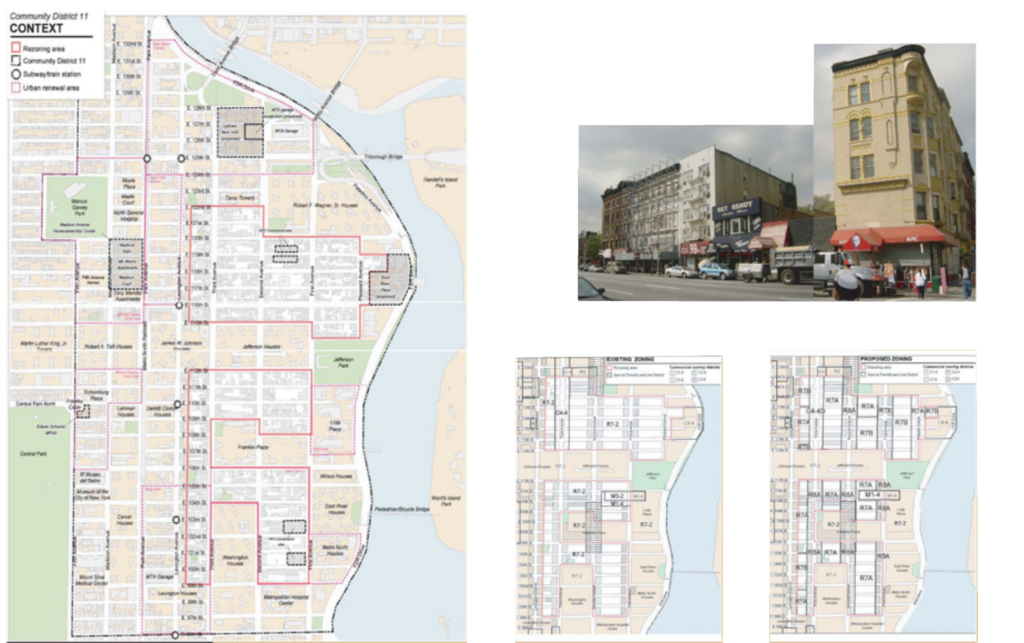
Location: Between Lexington Avenue and First Avenue from East 99th Street to East 112th Street and East 115th Street to East 122nd
Date: Adopted 2003
Sponsor: New York City Department of City Planning, Community Board 11 and CIVITAS
Design: NYC Department of City Planning with CIVITAS
Credits: Courtesy of Marcha Johnson and Emmanuel Thingue
Frederick Douglass Boulevard Rezoning
The rezoning of the residential blocks centering on Frederick Douglass Boulevard and the area from 110th Street and 124th Street between Adam Clayton Powell, Jr. Boulevard and Morningside Park followed a planning study sponsored by Manhattan Borough President C. Virginia Fields. The plan was developed by Columbia University’s Urban Technical Assistance Program (UTAP) in two phases. The first inventoried opportunity sites for development of new infill and renovated housing to be sponsored by HPD. The second phase elaborated on what should be built and informed HPD’s request for proposal process on the various sites by recommending urban design guidelines for new development. Along with the East Harlem Rezoning, City Planning’s adoption here of changes from existing residential zoning designations R7-2 and R-8 (see map above left) to R7A and R8A (above right) established the precedent for “contextual zoning” in residential neighborhoods with a low- or mid-rise historic fabric. These new categories set minimum and maximum streetwall heights and control overall building height in order to discourage “towers in the park” development.
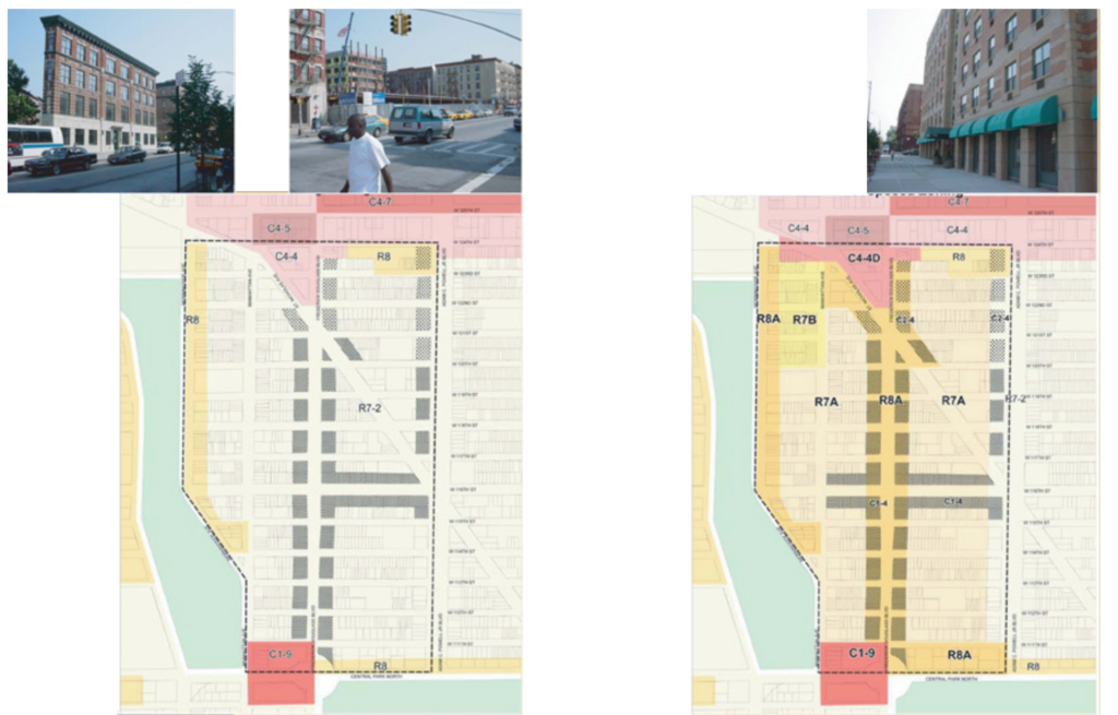
Location: Frederick Douglass Blvd., Morningside and Manhattan Avenues, and Adam Clayton Powell, Jr. Blvd, West 110th Street to West 124th Street
Date: Approved 2003
Sponsor: New York City Department of City Planning with Manhattan Borough President C. Virginia Fields
Design: New York City Department of City Planning based on recommendations by Columbia University Urban Technical Assistance Program (UTAP)
Credits: NYC Department of City Planning; photos by City College Architectural Center
Community Board 9 197a Plan
CB9 completed its 197a Plan in 2004–authorized under a provision in the City Charter enabling Community Boards and other entities to submit community-based plans for consideration by the NYC Department of City Planning and, ultimately, by the City Council. As a planning tool, 197a plans primarily address land use and zoning–or those issues that fall under the purview of City Planning. After several attempts over the past decade, CB9 was sucessful in completing its plan last year, working with financial and technical support from Harlem Community Development Corp. (HCDC) and consultants from the Pratt Institute Center for Community and Environmental Development (PICCED). PICCED has successfully advised other communities on their plans. The catalyst for CB9 this time was Columbia University’s petition to have the Manhattanville area rezoned from manufacturing to other uses.
CB9’s plan offers recommendations on issues from land use to preservation to the environment. The zoning scheme recommends “contextual zoning” for most existing residential areas and a more finely grained approach for Manhattanville to be achieved through designation of a special purpose district.
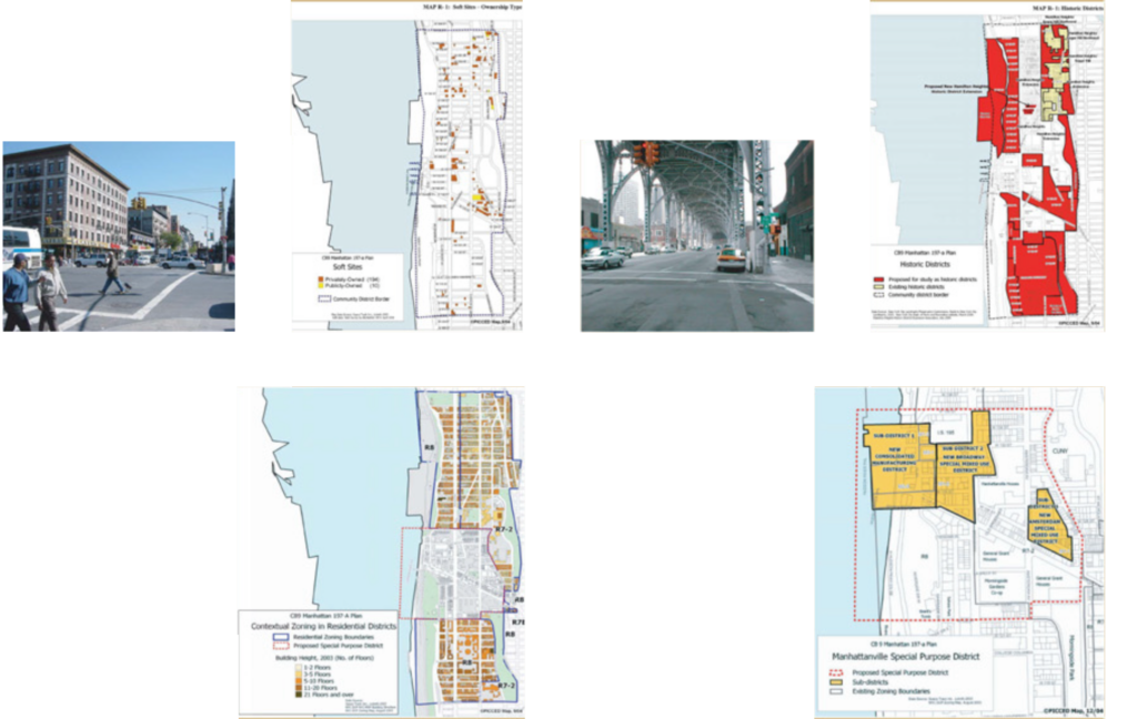
Location: Community District 9 comprising Morningside Heights, Manhattanville and Hamilton Heights between West 110th and 155th Streets
Date: Issued fall 2004
Sponsor: Community Board 9, Manhattan
Design: Pratt Institute Center for Community & Environmental Development (PICCED)
Credits: PICCED (maps); photos by City College Architectural Center

This entry is licensed under a Creative Commons Attribution-NonCommercial-ShareAlike 4.0 International license.