
Providing a setting for the building boom, civic groups, residents and elected officials have shown leadership and ingenuity in improving Harlem’s open space network. These efforts extend from Harlem’s historic landscape parks revealing Upper Manhattan’s rugged terrain, to the infrastructure of its streets and boulevards, to its abundant shoreline.
Neighborhood coalitions and “Friends” groups have been instrumental in adopting parks to assist with safety, clean-up and seeking outside funds to supplement over-stretched Parks Department budgets. The Historic Harlem Parks initiative is one of four “catalyst programs” of Partnerships for Parks, a public-private venture that provides capacity building support and community organizing around programming and targeted improvements in Jackie Robinson Park, Marcus Garvey Park, St. Nicholas Park and Morningside Park (pictured above, clockwise from top). “Take Me to the River,” an initiative sponsored by Borough President C. Virginia Fields, the Riverside Park Fund, the West Harlem Art Fund and a coalition of community groups has engaged in planning to improve access to the Hudson River in Riverside Park north of 145th Street.
On the waterfront, community groups have begun to see victory in recent years as the city’s approach has evolved from top-down and developer-driven to one that is asset-based and rooted in a community’s vision. This change has allowed for the conversion of disused, former industrial stretches of shoreline to be rebuilt for the community’s enjoyment.
Within neighborhoods, too, many of Harlem’s streets are experiencing a makeover. Complementing historic preservation of the building fabric and a contextual approach to infill construction, the streetscape itself is being rebuilt with sensitivity to Harlem’s scale, architecture and history. The projects of the Harlem Gateway initiative along 110th Street set a rigorous standard in streetscape design that should inspire quality and attention to detail as other corridors are rebuilt. These projects also demonstrate how a sense of Harlem’s cultural and historical heritage can be expressed in its open space through public art that is both contemporary and relevant to its context.
In this section:
- Riverbank State Park
- Malcom X Plaza and Malcom X Boulevard Improvements
- Harlem Gateway / Frederick Douglass Circle
- Ralph Ellison Memorial
- Harlem River Park
- West Harlem Piers Master Plan & Waterfront Park
Riverbank State Park

Location: West 137th to 145th Streets along the Hudson River
Date: Opened 1993
Sponsor: New York State Office of Parks, Recreation and Historic Preservation
Architect: Richard Dattner with Joseph Coppola and Bill Stein of Richard Dattner & Partners Architects; Abel Bainnson Butz, LLP, Landscape Architecture
Cost: $130 million
Size: 28 acres
Credits: City College Architectural Center (top and bottom left); Richard Dattner & Partners Architects (top right); Aero-Industrial Communications (bottom right)
An urban rooftop 69 feet above the Hudson River, the award-winning Riverbank State Park sits atop the North River Sewage Treatment Plant, built between 1985-7. The only state park in Manhattan, Riverbank offers a wide variety of recreational facilities including an Olympic-size pool, a lap pool, skating rink, tennis and basketball courts, and full-size playing fields.
The park’s opening in 1993 was bittersweet as it represented a give-back to the community for hosting the unwanted treatment plant. A 1989 investigation revealed operational flaws, supporting claims that emissions from the facility were causing increased respiratory illnesses among area residents. A lawsuit brought by West Harlem Environmental Action (WE ACT) and others yielded a $55 million overhaul to the plant and a $1.1 million fund for environmental health and quality of life programs. Today the park is heavily used by the community, attracting four million visitors yearly. A unique feature is the Totally Kid Carousel from 1998, designed by artist Milo Mottola with 36 local elementary school students and commissioned under the NYC Department of Cultural Affairs Percent for Art Program.
Malcom X Plaza and Malcom X Boulevard Improvements
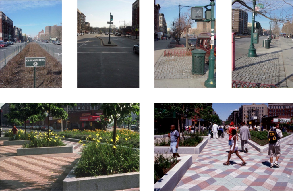
Location: Central Park North / West 110th Street between Fifth Avenue and Frederick Douglass Boulevard / Central Park West
Date: Phase 1 – Harlem Gateway Corridor / 110th Street completed 2002; Phase 2 – Frederick Douglass Cir. completed in December, 2005.
Sponsor: New York City Department of Transportation (US Department of Transportation TEA-21 Program); Congressman Charles Rangle, Manhattan Borough President C. Virginia Fields, Council Member Bill Perkins and Council Member Phil Reed
Design: New York Department of Design and Construction with Ken Smith Landscape Architect, J-P Design Group, Hardy Holzman Pfeiffer Associates and Cityscape Institute (Phase 1); URS Corporation, Quennell Rothschild & Partners, J-P Design Group and Central Park Conservancy–Cityscape Program (Phase 2); Gabriel Koren, Sculptor, and Algernon Miller, Site Artist (Phase 2)
Cost: Harlem Gateway Corridor / West 110th Street (Phase 1) – $4.5 million; Frederick Douglass Circle (Phase 2) – $10.2 million
Credits: Courtesy of Quennel Rothschild; Central Park Conservancy–Cityscape Program
Malcolm X Plaza is a relatively new open space at the former triangle where St. Nicholas Avenue met Lenox Avenue and Central Park North. With the closure of one short block, the extra space allowed for this lively urban garden framing views in several directions. The view up St. Nicholas Avenue is toward Harriet Tubman Square at Frederick Douglass and 121st Street. This space is to be rebuilt with a monument to the abolitionist (Manhattan Borough President C. Virginia Fields is sponsoring the project).
The opportunity for Malcolm X Plaza came about through Cityscape Institute’s leadership in seeking federal transportation funds to supplement the final phase of the rebuilding of Lenox Avenue/Malcolm X Boulevard from 1 10th to 145th Street. The reconstruction occurred in phases over several years. The supplemental funding allowed for upgrading the plantings of the medians and street trees, as well as new historic roadway and sidewalk lighting between 110th and 118th Streets.
Harlem Gateway / Frederick Douglass Circle
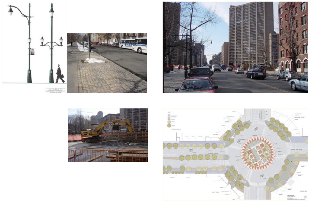
Location: Malcom X Plaza bounded by Central Park North (West 110th Street), Lenox Ave. and West 111th Street; Malcom X Boulevard (Lenox Ave.) between 110th Street and 145th Streets.
Date: Plaza completed in 2000 as part of final phase of Lenox Avenue
Sponsor: Council Member Bill Perkins (capital funding for plaza)
Architect: NYC Department of Design & Construction; Ken Smith Landscape Architect.
Cost: $850,000 (plaza)
Credits: Courtesy of Ken Smith Architecture (right top and bottom)
The goals of the Harlem Gateway are twofold–to evoke the historic landscape of Central Park and to celebrate entry to Harlem by commemorating important figures from its history. Phase 1 consists of streetscape and lighting enhancements for Central Park North/110th Street from Fifth Avenue to Frederick Douglass Boulevard. Designs for tree planting, street furniture and paving unite both sides of the street with vistas into the park, while specially designed light standards will incorporate interpretive signage. Phase 2 consists of the the reconstruction of Frederick Douglass Circle where 110th Street and Cathedral Parkway meet Central Park West and Frederick Douglass Boulevard. The design creates a traffic rotary and a central plaza honoring Douglass. The design mixes abstract symbology and text with a figurative sculpture of the 19th century abolitionist and writer.
Although it preceded this project by a few years, the creation of a landscaped plaza and sculptural monument to jazz legend Duke Ellington at Fifth Avenue and Central Park North lent inspiration to the Harlem Gateway concept.
Ralph Ellison Memorial
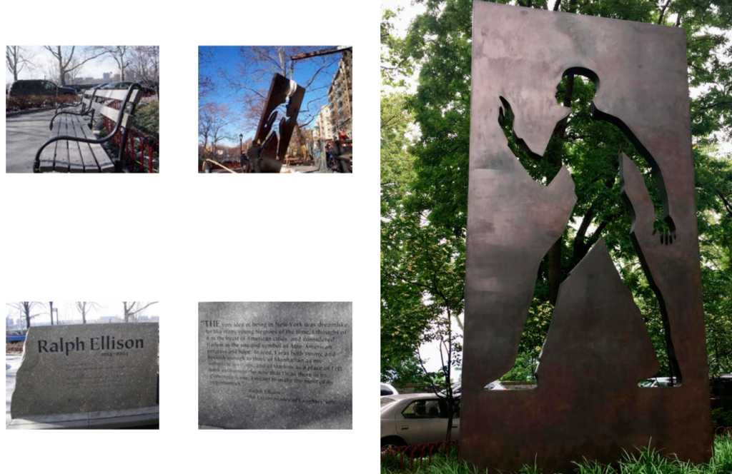
Location: Ralph Ellison Island – Riverside Drive between 149th and 153rd Street
Date: 2002
Sponsor: Ralph Ellison Memorial Committee and the Riverside Park Fund with New York City Department of Parks and Recreation
Design: Elizabeth Catlett, Artist, and Ken Smith Landscape Architect with NYC Department of Parks and Recreation
Cost: $1 million
Credits: Courtesy of John Reddick, Central Park Conservancy-Cityscape Program
A memorial sculpture honoring writer Ralph Ellison stands on a landscaped island alongside Riverside Drive between West 149th and 153rd streets. The sculpture by the distinguished African American artist Elizabeth Catlett occupies a paved plaza facing the Beaumont Apartments where Ellison lived with his wife Fanny for much of his adult life. The artwork depicts the silhouette of an “invisible man” removed from the mass of a monolithic bronze tablet 15 feet high by 10 feet wide. The island had its plantings, fencing and walkways refurbished as part of the project.
This intimately scaled but significant open space is truly of its place and is a gift from the author’s neighbors. Ellison frequented the island, which offers on overlook onto Riverside Park and the Palisades. He was a member of the American Academy of Arts and Letters located nearby on 156th Street and is buried in Trinity Cemetery. The Ralph Ellison Memorial Committee worked with the Riverside Park Fund, the Parks Department and a broad-based coalition of community residents on selecting overseeing the design of the plaza and landscaping.
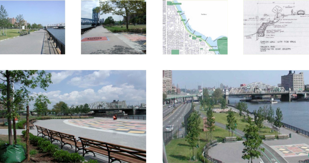
Harlem River Park
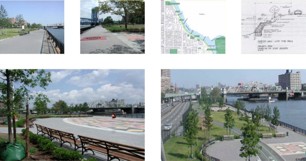
Location: Harlem River Drive between East 135th and 139th Streets (Phase 1); 139th to 142nd Streets (Phase 2); 125th to 135th Streets (Phase 3)
Date: Opened 2002 (Phase 1)
Sponsor: Harlem River Park Task Force
Design: NYC Department of Parks and Recreation, Emmanuel Thingue, Parks Designer (Phase 1); Marcha Johnson and Ricardo Hinkle (Phase 2)
Cost: $3.9 million to date (Phase 1) with additional improvements sought; $4 million est. for Phase 2 (committed); $9 million est. for Phase 3 ($5 million committed)
Credits: Courtesy of Thomas G. Lunke, Harlem Community Development Corp. (HCDC).
This park represents the reclamation of a strip of land between the Harlem River Drive and the waterfront formerly controlled by the Department of Ports and Trade. The goal is to create continuous waterfront access with a dedicated bikeway, seating and landscaping between 125th and 145th Streets– connecting the East River and Harlem River Esplanades. The Harlem River Park Task Force has broad representation from Community Boards 10 and 11 and elected officials at all levels; NYS Harlem Community Development Corp. and East Harlem community and economic development organizations, tenants associations of nearby housing complexes and citywide parks and waterfront advocacy groups.
Phase 1, complete from 135th-139th Streets, is a linear park with lawns, plantings, seating and generous bikeway adjacent to a restored edge at the bulkhead. Funding obtained for Phase 2 will extend the park north to 142nd Street. Phase 3 will feature a naturalized edge of stones and native plantings south to 125th Street. Although this last phase awaits repairs on the roadway and Harlem River bridges, the HRP Task Force calls for a temporary path alongside DOT construction sites between 125th and 135th Streets.
West Harlem Piers Master Plan & Waterfront Park
Location: Hudson River Piers between St. Clair Place and West 133rd Street
Date: Construction began in 2005
Sponsor: NYC Economic Development Corp. (EDC) with the West Harlem Working Committee / Community Board 9 and WE ACT for Environmental Justice
Design: W-Architecture and Landscape Architecture
Cost: Waterfront park improvements estimated at $16 million
Credits: WE ACT for Environmental Action (top center and right); W-Architecture and Landscape Architecture, courtesy of EDC (all other images)
Construction of a park and piers along the Hudson River waterfront in West Harlem represents the partial realization of a long-term community-planning process. WE ACT for Environmental Justice and Community Board 9 kicked off the Harlem-on-the-River initiative in 1998, resulting in a community-based planning framework for waterfront access and usable open space, as well as economic development, transportation, education and culture, urban design, environmental restoration and historic preservation. These ideas formed the basis for NYC Economic Development Corporation’s West Harlem Master Plan.
The park itself, designed by W-Architecture and Landscape Architecture, who also led the Master Plan team, will offer open green space and new piers for fishing and excursions along the water, a bike path making a crucial “missing link” in Manhattan’s Waterfront Greenway, kayak facilities, and likely a small, multi-use structure for commercial and/or community use. Streetscape improvements on West 125th Street from Broadway to the park are also envisioned. The city and state are both providing funds for construction, and the Upper Manhattan Empowerment Zone (UMEZ) has pledged $5 million to the project.


